
St
Martin/St Maarten
17
Apr 2012 18 02.7N 063 05.7W
Anchored
on French side, inside Simpson Bay Lagoon.
St
Martin is the smallest island in the world to be divided between 2
countries.
We
entered on the Dutch side, under the Dutch bridge into the lagoon,
but then motored straight across the charted border line to anchor on
the French side, under the charmingly named Witch's Tit. Here it is
free to anchor and to check in, over there it is not free. View is
pretty much the same.
The
island is a weird hybrid. Plenty of lost souls go aground here, or
run small businesses serving the needs of cruisers and paying no tax.
Health care is free here too, as the north side is part of the France
and therefore the EU.
We
spent too much time here, doing the rounds of the 3 huge chandleries,
buying cheap food on the French side, and cheap alcohol on the Dutch
duty free side. The french supermarkets were a good place to stock up
with dried fruit, nuts, toiletries, cheese, pasta – enough to last
until the USA. A weekly flea market was an ideal place to pick up
charts of the US and Bahamas.
There
are no physical borders between the 2 sides of the island. Buses run
right around the island. It really is most bizarre.
We
bought antifouling here (ABC, used by the US Navy, 4 gallons for
US$680). You can buy stuff here that is banned everywhere else.
St
Martin has a great music scene, lots of local live music, and Stu did
a couple of open mike nights, and even bought a microphone for his
guitar so he can be amped up. Too many happy hour bars for your
health though.
We
picked up a second hand 8HP outboard. Stu seems to be having a
mid-life crisis about the need for speed in our little dinghy.
Antigua
Classic Week.
20
April 2012


Having
blown out an opportunity to crew aboard Storm Vogel, as we couldn't
see a weather window to get back to Antigua, suddenly one opened up
and we were able to sail back 'uphill' 120 miles to arrive the day
before the racing. Unfortunately Ian, the skipper, had filled all his
places mostly with young talent and totty, so we were relegated to
observing and photographing the race fleet. This was a big
disappointment but way less tiring. We watched our friend Phil (Miss
Molly) exhaust himself on the mainsheet position all week, and we
loitered and enjoyed the free entertainment and hospitality of
Antigua week, and drooled all over the lovingly varnished yachts.
British
Virgin Islands.
25
April 2012
The
morning SSB radio net was still going strong but we felt like
stragglers as most of the other boats were well 'ahead' of us. We had
a lovely 'downhill' sail, and I tied Stu to the mast to avoid the
temptation of stopping at St Martin again, in case we never left.
LAT
18d 29.4N LONG 064d 22.8W
We
went all the way to Virgin Gorda and checked in at Gun Creek, a new
check-in post – we were back on British soil again!
The BVI's are a very popular charter base and with good reason, lots of lovely bays, short sails between stops, cheap rum and endless sunshine. But, other than inflated food prices, the downside is that many bays are full of mooring buoys which pleases charterers on holiwols, but not cruisers on a a budget. It is possible to anchor at the edges of the mooring fields, but it obviously reduces your choice of good holding, good shelter and reasonable depth of water. Still we could enjoy 10 days in the BVIS for about £2000 less than the charterers and a minimal carbon footprint too – very little fossil fuel suffered for us to get here!
The BVI's are a very popular charter base and with good reason, lots of lovely bays, short sails between stops, cheap rum and endless sunshine. But, other than inflated food prices, the downside is that many bays are full of mooring buoys which pleases charterers on holiwols, but not cruisers on a a budget. It is possible to anchor at the edges of the mooring fields, but it obviously reduces your choice of good holding, good shelter and reasonable depth of water. Still we could enjoy 10 days in the BVIS for about £2000 less than the charterers and a minimal carbon footprint too – very little fossil fuel suffered for us to get here!
Jost
Van Dyke Island, Great Harbour
Tempted
by the famous watering hole of Foxy's, which everyone seemed to know
about, we ventured ashore and had a very overpriced and over-rated
meal and a few rum punches, with Clare and Mike from Siga Siga. One
time spit and sawdust beach-sailors bar now turned tourist
attraction.
On
Siga's advice we went over to:
Cane
Garden Bay
Tortola, 27 April


This
anchorage ticks all the boxes, not too deep, not too many moorings,
pretty good shelter, fantastic wildlife, clear water, excellent
snorkelling nearby, rum factory ashore and low-key bars with locals
and live music. Does it get any better than this? We chilled out and
watched the pelicans diving for their dinner, until Clare decided we
should walk to the bay next door, where there is even better
snorkelling. It did look like a big hill from the anchorage, but
appearances didn't quite prepare us for the gradient or the length.
Luckily we were quickly offered a lift in the back of someone's
truck, which we gratefully accepted, and snuggled up to the greasy
spare wheel. As we got higher and higher, we wondered if we would
ever make the journey back without a similar friendly local to
assist. Well, we had an excellent swim and we just about made it up
the hill to get home, with plenty of puff stops to admire the views.


We
had a little lunch excursion to nearby Sandy Cay, just a few miles
out of Tortola, with a wet and bouncy dinghy landing and a walk
around the nature path on the tiny paradise island.

All
too soon, it was time to move on, and we waved Siga Siga off as they
were headed south to Grenada for hurricane season. We went back to
Jost Van Dyke to check out at Great Harbour, and took advantage of
sundowners at the Soggy Dollar Bar in White Bay, another beach bar
making too much of it's reputation, but with very acceptable views.

The other Virgin Islands and visa issues.
There
are 3 groups of islands, British, US and Spanish. The USVI's are full
of Americans on cruise ship and cheap rum-fuelled holiday-makers
-like Benidorm with snorkelling. You do need a US visa to go there by
boat (we had ours from NZ already) and don't even think of landing
there by boat if you haven't got one – you will be fined big-time. The only
way around this ( at this moment in time) is to leave the boat in the
BVI's and go by ferry to the USVI's and you can get a 90 day multiple
entry visa, then go back and get your boat. Whether this works or
not, is down to the officer of the day, so best to get a proper 10 yr
visa at an American embassy beforehand.
We
decided that we would have enough American culture this coming
summer, so we bypassed the US islands and went to Culebra, a part of
Puerto Rico or the Spanish Virgin Islands. Well, you have to forgive
our ignorance, but we were about to discover that the only thing
Spanish about these islands is the language they speak. They have
been owned by the USA since the Spanish-American war of 1898, they
are all bilingual and USA citizens, though not a state so they cannot
vote. The same visa issues apply here, as to the USVI's and the USA.
Ensenada
Honda, Culebra, Puerto Rico.
3
May 2012

We
anchored in Culebra and prepared to go ashore for the first time in
US waters, with our new shiny American visas in our passports. The
first challenge, is that the very first thing you must do is
phone Customs and Border Protection (CBP)on a toll-free number posted
on the public dock to tell them you have arrived. We phoned
beforehand from the BVI's but they DO NOT WANT TO know about you
until you arrive. This is all very well, but we don't have an
American phone, most European phones don't work on their network and
there are no public phone boxes. We'd had a heads-up about this from
the SSB net, so we went to the infamous Dinghy Dock bar and asked
very nicely if we could borrow their phone while we had a drink (well
it is a toll-free number). It takes a while, as they want to know all
sorts of things about you, just short of your inside leg measurement.
They will tell you what to do next, likely to be that you should go
to the airport in the morning to complete check-in formalities, with
boat papers in hand.
So
next morning, off we went on the 20 minute walk to the airstrip. The
CBP officers were exceptionally polite and helpful with the form
filling. We were told to list our ships stores – which could have
taken us all day. We asked what they really wanted to know about –
mangos from the USVIs and tobacco, were their biggest cause for
concern. So our list started NO TOBACCO and NO MANGOS, and then a
brief list of stuff like eggs, cheese, salami, fresh meat, and
spirits, wine and beer. They were very happy with this, and we were
ecstatic that no-one was going to come to our boat and search it,
confiscating all our french cheese.
It
costs $19 for a Cruising Permit for one year to cruise the USA (even
if you leave, go to the Bahamas, and enter again) and means that you
should not have to clear customs in each port or pay entrance fees
anywhere else – however, you are obliged to phone CBP whenever you
move within the US, usually state to state, but from anchorage to
anchorage in the north, which is a real pain.
Bizarrely
it costs more ($36)to get a permit if you come from USVI's.
You
do get a white card (I-94)with your B2 visa in your passport while in
Puerto Rico/Culebra, and have to surrender this when you check out
for the Bahamas – you get another one on entrance to the USA again.
It's worth doing this, so that your 6 month stay in the USA starts
from later in the year.

We
passed a very pleasant week in Culebra, joining the local hippies
that have drifted there and stayed. It hosts an odd bunch of mad
dropouts, but is a delightful little island with world-class
snorkelling in crystal water. We braved the heat and cycled the whole
island to explore the other snorkel sites.
We
would have liked to have spent more time in Culebrita and the main island of Puerto
Rico, but were running out of time as ever, and so we checked out and
set off to the Bahamas.
Note on Turks and Caicos Islands.
As
of this year, it costs $50US to check in, $50 check out, for up to one
week. If you stay more than one week, it costs $300. This is the same
price to cruise the whole of the Bahamas for a year, which has a lot
more islands, so many thrifty cruisers voted with their keels this
year and bypassed the Turks and Caicos - we didn't have time to do
them justice at any rate.
Bahamas

This
was the last down-tradewind trip for us this year, taking just over 4
days and 500 miles from Culebra. The Bahamas mark the transition from
tropics to northern latitute sailing. We aimed for the most upwind
island with check in facilities, dropping behind the reef of
Mayaguana to anchor.
Mayaguana
13 May 2012
Anchored
Abrahams Bay 22 21N 072 59W


It takes a lot of getting used to, much of the Bahamas is little more than 3-4m deep, so the bottom is very close to the bottom of the boat, and there are lots of poorly charted coral heads that grow up like stalacmites – with sharp pointy bits best avoided by boat bottoms. You can see the shallow water from afar on Google maps. It makes a real purty colour.
Bahamas
navigation involves one of us standing out on the bow, looking ahead
to ensure we don't stray into sharp or shallow bits – its a bit hot
out there in the sun too. You are supposed to travel with the sun
overhead so that you can see down into the water without reflections,
so ideally you need to be in, with your anchor down by 4pm each day.
This is much easier said than done, if you need to cover a number of miles in a day between safe stops.
At
Mayaguana the sun beat down on us as we arrived and we could easily
get our eye in to spot the coral heads, so we threaded our way in.
The only protection from the sea is behind the shallow reef, which is
not so shallow at high water, so conditions can change throughout the
day with the height of tide. At high water with the wind from the
south you are anchored at sea, in shallow rolling waves!
It
took us two attempts to visit the customs office, as their hours are
erratic to say the least. The hardest bit is handing over the US$310 –
the paperwork was very straightforward, and even included a fishing
license automatically.

Mayaguana
is a one horse town, but a useful port of entry.
Conception
Island.
Anchored
23 51N 075 07W
Absloutely
georgeous place, with a good anchorage, sandy beach. It is a national
park so nothing ashore. Had a fun day kayaking up the river with
Yindee Plus in their dinghy.

 |
| Shark - only a baby |
 |
| mangroves |
We
saw a beautiful 55' yacht being salvagedoff the north of the island.
The owners had set a waypoint into their chartplotter a few hundred
meters off a reef – then trusted it instead of his eyes. They went
straight up on the reef and holed the boat. The salvagers did all
they could to refloat it, but the pumps were not coping. If they let
it sink on the reef there is a humungous fine to pay, for polluting
the national park, so the boat was towed out to deep water and
allowed to sink. We were weeping at the waste of all that gear on the
boat, now at the bottom of the sea – thousands of pounds worth of
winches, rigging, hardware. We wished we'd had half an hour on that
boat with a couple of screwdrivers.
Georgetown,
Exumas
This
is the main town of the chain of islands called the Exumas.
23
31N 075 44.57W
On
the way in we discovered how inaccurate most charts are for the
Bahamas. Not much of the $300 check-in fee goes towards naviagation
aids, and those that exist are weird and wonderful shapes and
colours. Everything is low lying and there are few transit markers so
navigation is tricky. We were plagued by overcast weather the whole
time we were in the Bahamas. Even on the bow of the boat with
polarised sunglasses and crystal clear water, it is impossible to
tell 1m from 10m of water. We gently nudged a rock off the entrance
to Georgetown, no harm done, but it made us nervous at all times.
(For
going back to the Bahamas we have acquired Explorer charts, NV charts
are also good)
Georgetown
was a good stop for laundry, diesel and a supermarket. Whilst cheaper
than the outer islands, it is a lot more expensive than other places
so far. I found some bargain artesan parmesan for $3 a wedge. I think
it was supposed to be $30, and mispriced, so I snaffled a bunch of
them. Less of a bargain was a case of 24 cans of beer -$65 US.
All
stocked up we continued on up the island chain.
Normans
Pond Cay
Never
again will I anchor somewhere with 'pond' in the name. Think hot, low
lying, mosquito and noseeum infested swamp. Our mosquito nets were no
match for these guys and we spent an extremely uncomfortable night
scratching and swatting. In the morning the bed was covered in tiny
dead bodies.


Rays
and nurse sharks swim all around the boat, and are unfazed by
swimming humans.
Warderick Wells Cay, Exumas.
Can't anyone make an underwater camera that doesn't leak?
Big
Majors Spot/Staniel Cay
Anchored
24 10.6N 076 26.7W
This
is a really popular spot for a big bunch of cruisers, and we came
here to shelter from a pretty nasty blow going through.
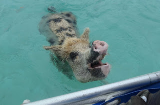
The
little town used to have a pig problem. The pigs made the town smelly
and attracted flies. So someone suggested they deport the pigs to
their own desert island where they could smell as much as they like.
The pigs flourished, the cruisers feed the pigs their organic
rubbish, and the pigs entertain the cruisers. Rubbish, pig, smell,
and fly problem solved – since the pigs are so keen on cruiser
rubbish they swim out to you as you approach, so they are regularly
bathed too. 


A
beach party, BBQ, pot luck was arranged for one evening, a
bring-your-own beer, food to share, firewood, and an instrument if
you have one.
Some
pigs came too, they were not on the menu .

 |
| Arriving with firewood |
Cruisers make their own fun...there was not a green
vegetable on show in the pot luck though, fresh provisions are few
and far between and cruisers closely guarded their last few green
things.
In the local shops here for 2
pints milk, 1 loaf of horrible sliced bread and 12 eggs - $15 US ! Come prepared with bilges bulging.
Swimming
and snorkelling opportunities were all around. Nearby was Thunderball
grotto – used in and named after the James Bond film. You
dive down into a cave filled with over-friendly fishes. There are
very strong currents so you have to swim at slack water, or risk
ending up out at sea without a paddle.
 |
Can
you spot Ray the ray?
|
Warderick Wells Cay, Exumas.
Another
national park. We took a mooring for $20/night. It is possible to
anchor about 1 mile away and dinghy in, but the weather was
uninspiring, so we splashed out for a change.
The
island is very natural and has some walking trails and caves to
explore. In the water there are coral gardens for snorkelling. We are
cursing Olympus and the not so waterproof camera – it would be
great to have some underwater shots.
 |
| Kids and caves |
 |
| walking trails |
I
swam against the strong currents to stay in one place and watched an
enormous lobster go visiting his friends cave to cave. Neither he nor
his friends would survive outside the park for long. The park is a no
take zone, so the wildlife is special and big. At one point a 10'
shark swam right underneath me. Despite having been told numerous
times that they are harmless, I shot 6' out of the water and screamed
SHARK. So did the big fearless guys next to me. Warderick Wells
sports one of the most beautiful beaches we have seen so far.
Incredible turquoise bath water.
 |
| Bathtime |
Highborne
Cay
24
42N 76 49.8W
More
motoring between the islands. Having to move 30 – 40 miles in a
day, and to arrive while the sun is still high, means that the engine
gets used a lot more than we would like.
More
very impressive snorkelling, crystal clear water and lots of fishes.
We took it in turns to stay in the dinghy while the other swam, so
that the currents couldn't take us too far away from our transport.
When you are swimming on your own, you often turn around to see a
malevolent looking barracuda stalking you. Can't anyone make an underwater camera that doesn't leak?
Nassau
A
friends mooring. 25 04.5N 077 18.7W We never intended to visit Nassau as it is a pit compared to the rest of the Bahamas – and it is where the cruise ships come to.
But it was a good opportunity to at last catch up with our radio net cruiser friends – we are always bringing up the rear – and give moral support to Pete and Kourtney on Norna. They were having horrible problems with their diesel engine, only 100 miles from the end of their 3 year cruise and their home port.
We had a great time with Yindee Plus, Innamorata, Norna, Tactical Directions and some new shorebased friends, Ken and Sheila, ex cruisers who have gone aground in Nassau.
We took on more fuel here, what gas guzzlers we are. $5.40/gallon. 89P/litre
Green
Bay/Rose Island 4June 2012
anchored
25 06.1N 77 11.W
After
sitting out another batch of bad weather, we headed to Kens favourite
weekend beach – Green Bay, bit of a misnomer, it is anything but
green and no roses on Rose Island. We had a great musical evening
aboard Tony's catamaran Tactical Directions, the perfect venue for
deck lounging of an evening.


Time
is ticking by now, and 2 tropical storms have formed and gone up the
US coast before the start of storm season on 1 June. Nervously
listening to the weather info every day. Not much in the way of free
internet here, not even in the bars and cafes ashore in the bigger
towns.
Royal
Island
anchored
25 30.92N 076 50.8W
A
tiny 'hurricane hole' anchorage. Bet it would be very busy if a storm
did threaten.
Looks
like someone started to build a resort ashore, then forgot what they
were doing after the portacabins arrived. Glad they did too. Having
lots of thunder and lightening every evening now. Skies look very
sinister.
The
Abacos. Bahamas
Another
bunch of islands, with world-class snorkelling on the reefs. Can be
hard to find information on the diving and snorkelling sites, as the
dive shops like to keep that information to themselves.
Sandy
Cay
26
24.2N 076 59.6W
Incredible
snorkelling area, crammed with sealife. Spending every possible
moment in the water. This is our favourite snorkel site so far.
Hopetown
A
charming little harbour, though a bit twee and made pretty for
tourists. Fascinating lighthouse with excellent example of British
precision engineering.


No
anchoring in here, so we took a mooring ball. $15 – 20/night.
Someone unofficial comes to collect the fee from the boat.
This
is another 'hurricane hole' and plenty of people stay here all
through the season. Just the other side of the houses in the photo is the full fetch the Atlantic ocean - it would be gnarly
on a bad day.
Man
o War cay
26
35.9N 077 00.7W, anchored Caught up with Andrew and Clare on Eye candy for a proper dive, but strong currents made us abort at the last moment. Stu used the last of the air to scrub the bottom of the boat yet again. We are fouling up within a few days each time. The antifouling we put on in Turkey last year has fallen off and been rubbed off in just over a year – we usually get 3 years.
Andrew is always watching the weather and carefully studying the forecasts. He alerted us to a short weather window for heading up to the USA. It would only be a short one, but we were all ready to make the dash and be in closer proximity to safe harbours if a hurricane formed. There's no need to check out of the Bahamas, so we were not delayed by officialdom and could just leave. Once in the USA you send your paperwork back to the Bahamas to prove that you left.
North
bound to the USA . 11 June 2012
Everyone
has heard of the gulf stream and its north track up the US coast,
heading offshore at Cape Hatteras to cross over to bathe England in
balmy seas. We imagined a wide belt of water moving north like a
magic carpet. But in reality it is a thin piddle, not very wide at
all. Ideally we would have headed west until we were in the flow and
rode it north up the coast, but each evening violent thunderstorms
were travelling up it, being fuelled by the warm water. The storms
were very active. The stream changes position all the time. Passage
weather gives a 3 day forecast of its position ( we didn't know that
at the time)
 |
| dinner
So
we headed north west just outside the stream instead. Here we found
infuriating adverse currents. We carefully watched the weather
forecasts while at sea, and our slot was getting shorter and shorter
before the next storm was due to come through. We entered Charleston
after 450 miles and tied up at the marina as the ugliest storm clouds
we'd ever seen formed and swirled over the city. It looked just like
the stuff on those National Geographic weather programs.
|